Description
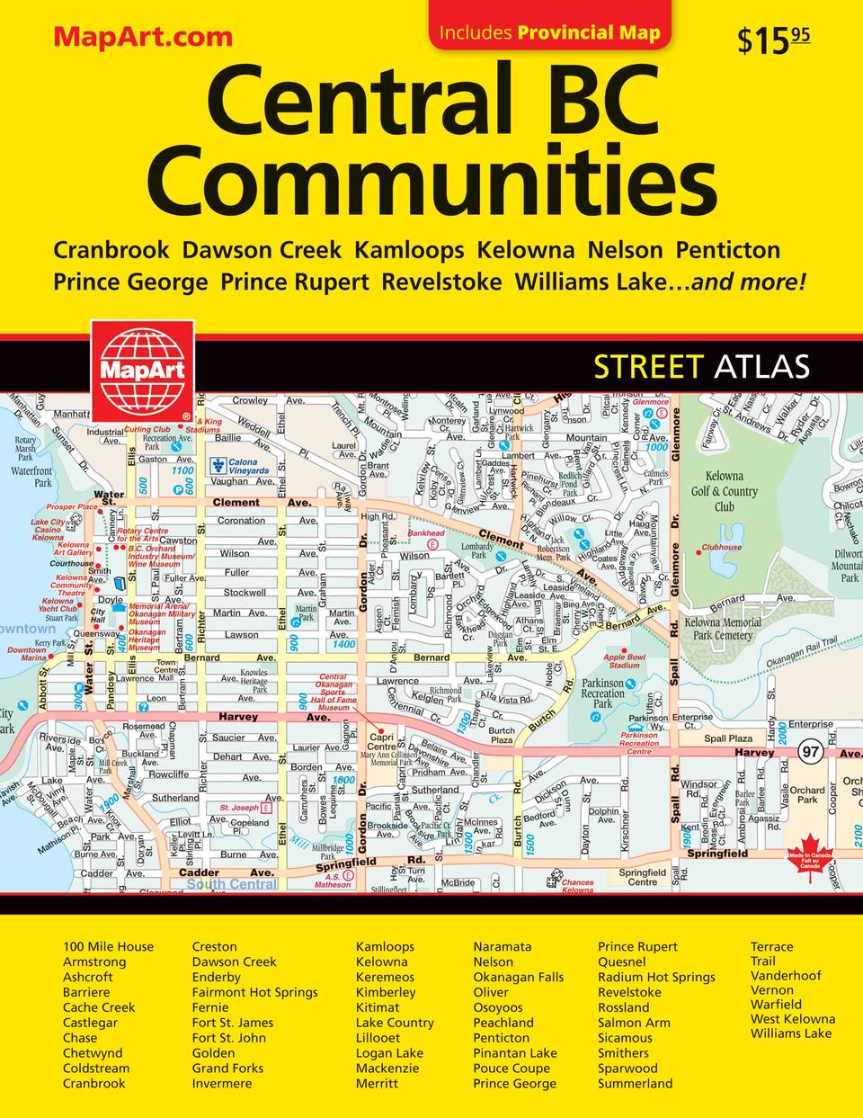
It’s the definitive auto companion for travel in this area, whether you are a resident or short-term visitor. It’s got all the features to make even the unfamiliar areas easy to navigate. Inside this 176 page atlas you will find detailed city mapping at 1:21,000 of 100 Mile House, Armstrong, Ashcroft, Barriere, Cache Creek, Castlegar, Chase, Chetwynd, Coldstream, Cranbrook, Creston, Dawson Creek, Enderby, Fairmont Hot Springs, Fernie, Fort St. James, Fort St. John, Golden, Grand Forks, Invermere, Kamloops, Kelowna, Keremeos, Kimberley, Kitimat, Lake Country, Lillooet, Logan Lake, Mackenzie, Merritt, Naramata, Nelson, Okanagan Falls, Oliver, Osoyoos, Peachland, Penticton, Pouce Coupe , Prince George, Prince Rupert, Quesnel, Radium Hot Springs, Revelstoke, Rossland, Salmon Arm, Sicamous, Smithers, Sparwood, Summerland, Terrace, Trail, Vanderhoof, Vernon, Warfield, West Kelowna and Williams Lake and Pinantan Lake at 1:25,000 as well as British Columbia provincial maps (1:250,000), locator maps, feature listings (points of interest, golf, hospitals and wineries), city map legend, provincial map legend, street index and provincial map indexes.
The detailed city map features include Trans-Canada highway, Yellowhead Route, divided highways, major roads, secondary roads, main thoroughfares, minor streets, lanes / private streets, pedestrian streets, interchange numbers, one way streets, street address numbers, railways, VIA Rail stations, bus stations, ferries, carpool parking, border crossings, international boundaries, provincial boundaries, municipal boundaries, recreation trails, parks / conservation areas, golf courses, commercial areas, cemeteries, institutional areas, industrial areas, special attraction areas, indian reserves, national defence, hospitals, tourist information centres, police stations, fire halls, libraries, points of interest, liquor stores, wineries, casinos, national parks / historic sites, arenas, community / recreation centres, pools, baseball, soccer, tennis, skiing, campgrounds, public and independent schools The detailed provincial map features include Trans-Canada highway, divided highways/interchanges, major roads (paved and loose surface), secondary roads (paved and loose surface, other road (paved and loose surface), unimproved/forestry roads, seasonal roads, ferries, distance between points (km), international boundaries, provincial boundaries, time zones, airports (scheduled service), border crossings, tourist information centres, hospitals, spot elevations, national parks/historic sites, provincial parks/recreation areas, wilderness/protected areas, forest reserves, icefields, campgrounds, downhill skiing, picnic sites, populated places, provincial capital and Indian reserves. Wire-O bound Proudly made in Canada!
21 x 27 cm (8.28 x 10.75 inches)
Provinces/Territories: British Columbia


